Business Details
21 Years
experience
Trusted Construction Solutions in San Antonio
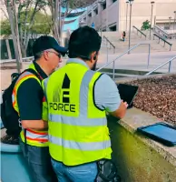
FORCE ASSET MANAGEMENT has been delivering comprehensive facility and construction solutions since 2005. Our expertise spans military, federal, and local infrastructure projects, utilizing cutting-edge technologies like LiDAR, BIM modeling, and aerial surveying. With a team of certified professionals, we provide end-to-end services from preconstruction planning to project closeout. Our commitment to safety, quality, and efficiency has earned us partnerships with over 180 clients across 25 states. We specialize in utility mapping, facility condition assessments, and construction management for complex infrastructure needs.Our FAA-licensed teams deliver precise geospatial data through advanced drone technology and terrestrial scanning. With 350+ completed projects and 1,200+ flight missions, we combine technical excellence with budget-conscious solutions. Our clients consistently recognize our ability to meet deadlines while maintaining rigorous QA/QC standards. From HVAC renovations to large-scale utility rehabilitation, we focus on optimizing operations and reducing maintenance costs. Our integrated AEC + FM approach ensures seamless transitions from design to facility management.
Services
As-built Laser Scanning
BIM Modeling
Condition Assessments
Roof Thermal Inspections
Aerial LiDAR Mapping
Utility Locating
GIS Analytics
Construction Management
Design Build Services
Facility Renovations
Details
- Year established: 2005
Highlights and features
- 18+ years of experience in construction and facility management
- FAA-licensed aerial survey teams with 1,200+ flight missions
- Certified facility management professionals (CFM) for optimized operations
- End-to-end project delivery from preconstruction to closeout
- Proven cost-saving solutions with $76,000 engineering savings
What people say
Quality data
Budget-friendly
Accurate deliverables
Dependable follow-through
Cost-saving solutions
Services
As-built Laser Scanning
Our as-built laser scanning creates precise digital models of existing structures using state-of-the-art terrestrial and aerial LiDAR technology. This enables accurate facility documentation for renovations, maintenance planning, and BIM integration. Clients receive detailed point cloud data and 3D models to support engineering analysis and construction coordination.
Facility Condition Assessments
We conduct comprehensive facility condition assessments covering architecture, mechanical systems, and infrastructure. Our certified professionals deliver detailed reports with lifecycle planning and capital improvement recommendations. This service helps clients optimize maintenance budgets and prioritize facility upgrades across large portfolios.
Construction Management
Our construction management covers full project lifecycle from preconstruction to closeout. Services include cost estimating, scheduling, QA/QC, and risk management. We ensure on-time, on-budget delivery for complex infrastructure projects while maintaining strict compliance with federal and military standards.
Aerial LiDAR Mapping
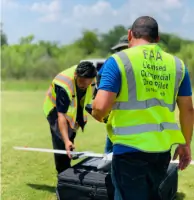
FAA-licensed teams perform aerial LiDAR mapping using UAV technology to create topographic models and utility maps. This service supports infrastructure planning, progress monitoring, and GIS database creation. Clients receive high-resolution orthomosaics and precise geospatial data for mission-critical applications.
Utility Locating & Mapping
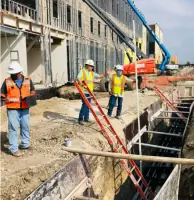
We specialize in utility locating and mapping using ASCE SUE practices to identify underground infrastructure. This service provides CAD/GIS-ready data for construction planning and maintenance. Clients benefit from reduced excavation risks and improved infrastructure documentation for federal, military, and municipal projects.
Questions
What construction services do you offer?
We provide full-cycle construction management including design-build, utility construction, and project consulting with safety-focused execution.
Do you work with federal/military clients?
Yes, we specialize in military, federal, and critical infrastructure projects with extensive experience at bases and government facilities.
What geospatial technologies do you use?
Our services include LiDAR, photogrammetry, terrestrial scanning, and GIS analytics for precise mapping and facility documentation.
How many states do you operate in?
We serve clients across 25+ states with nationwide project delivery capabilities for infrastructure and facility management.
Can you handle large facility portfolios?
Yes, we've completed assessments for portfolios with 400+ buildings and 35+ campuses using standardized reporting processes.
How do I request services?
Contact us via phone or email to discuss your project needs and schedule a facility assessment or construction consultation.