
Business Details
50+ Years
experience
Advanced Aviation GIS & Cartography Services
AED Aero, Inc. has been a leader in aviation GIS technologies and technical logistics since 1957. Our ISO 9001:2015-certified operations deliver advanced aeronautical navigation products, including ICAO Annex 4-compliant charting solutions, to civilian, defense, and government clients globally. We specialize in safety-of-flight data, obstacle databases, and geospatial information systems that support mission-critical operations. Our technical logistics division provides tailored solutions for aircraft maintenance, cyber data management, and mission system upgrades. With a team of experts and a focus on innovation, we ensure operational efficiency and compliance with international standards. Our 375 million square kilometers of GIS coverage and 1.3 billion SQL database elements underscore our global capabilities.We prioritize customer mission needs through cost-effective, timely delivery of products and services. Our veteran-owned status reflects our commitment to excellence and service to the defense community. We continuously invest in modern technologies to maintain our position at the forefront of aviation mapping and logistics. Our values of integrity, expertise, and customer-centricity drive every project we undertake.


Services
Aviation Mapping
GIS Database Development
Aviation Obstacle Databases
Aerial Surveying
Technical Logistics
Cyber Data Management
Mission System Upgrades
Digital Data Planning
3D Visualization
Infrastructure Management
Details
- Year established: 1957
Highlights and features
- ISO 9001-certified GIS products and services since 1957
- ICAO Annex 4-compliant aviation charting expertise
- Cost-effective technical logistics solutions for defense clients
- Veteran-owned business with global geospatial coverage
- 1.3 billion+ GIS database elements for precision mapping
Associations and certifications
- ISO 9001:2015
Services
Aviation Mapping
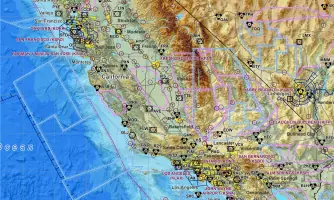
We create ICAO Annex 4-compliant aviation charts for civilian and military operations. Our digital mapping solutions enhance situational awareness and safety for search-and-rescue, firefighting, and tactical missions. Advanced GIS technology ensures precision for modern flight operations.
GIS Database Development
Our Gladiator Database manages 1.3+ billion elements for infrastructure, airspace, and utility networks. This system supports city management, healthcare logistics, and defense applications with integrated 3D visualization capabilities for operational planning.
Technical Logistics
We provide aircraft maintenance upgrades, cyber infrastructure protection, and digital data management. Services include ADS-B implementation, frequency spectral management, and lifecycle program support for defense and commercial aviation clients.
Aerial Surveying
Our modular payload aircraft collects LiDAR, IfSAR, and photogrammetric data. This technology enables high-precision topographic mapping and infrastructure analysis for government and commercial projects worldwide since 2019.
Cyber Data Management
We protect flight systems through secure data protocols and compliance solutions. Our experts develop digital management plans for ICAO Mode S addresses and satellite communication systems to prevent cyber threats to aviation operations.
People
Erik Anderson
President
Erik leads AED Aero's strategic vision for aviation GIS innovation. With decades of aerospace experience, he oversees technical logistics programs for defense contractors and government agencies globally.
Questions
What aviation GIS products do you offer?
We provide ICAO Annex 4-compliant charts, obstacle databases, and geospatial datasets for civilian and military flight operations.
Are your mapping solutions up-to-date?
Yes, our digital charts use current data unlike outdated paper-based systems, ensuring compliance with modern aviation requirements.
Do you support defense contractors?
We specialize in technical logistics for defense aviation, including cyber infrastructure protection and mission system upgrades.
Can you help with aerial survey projects?
Our modular payload aircraft collects LiDAR and photogrammetric data for infrastructure and environmental mapping projects.
How do you ensure data security?
We implement ISO 9001-certified protocols to protect aviation cyber systems from hacking and unauthorized access.
What geographic areas do you cover?
Our GIS database spans 375+ million square kilometers with operations in North America and overseas locations.